New: The Observer's live Fort Collins drone log tracks these flights as they show up on the radio.
The Fort Collins Drone as a City Resource Program launched in February 2026. Since then, we've heard a lot about its success from city leaders. However, the public does not have easy access to when, where and why drones are being used on a daily basis. The Observer is trying to address that gap.
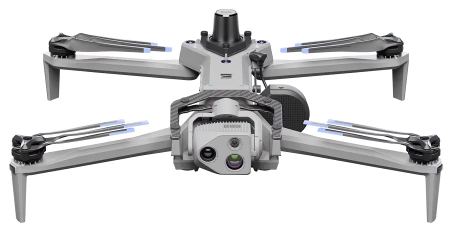
Fort Collins Police Department has three Skydio X10 drones from their Axon contract. These drones are deployed from two Poudre Fire Authority locations - Station 1 and Station 5. These drones can fly up to 45 MPH and typically have flight times of 30-40 minutes. Unfolded, they're about 2 feet by 2 and a half feet and weigh up to 5 and a half pounds with peripherals.
I have seen them flying around multiple times and have always wondered what kind of things they are using them for. Luckily, the Observer has been tracking some of the flights12.
The remainder of this piece is an AI-generated summary of the source material; it has been human-edited and reviewed for accuracy.
On the afternoon of July 13, 2026, Poudre Fire Authority engine crews were working a structure call and could not see the top of the roof. Command asked for a look from above. The exchange, verbatim from the radio:
"Cops can put a drone of course and then we can link it to our phone if you want thermal imaging on the roof. Do you want that?" — PFA, 13:22:39
"All right, copy. Yeah, 100, we'll take that drone. Thank you." — PFA, 13:22:55
"They're going to go ahead and respond to your location and then they'll launch the drone from there and show you the video." — PFA, 13:23:57
"Okay, the police are here. They're going to fly the drone. You want to come down and stand next to my rig so you can get an overview of the roof. He'll just link it to a screen for us." — PFA, 13:39:24
It took sixteen minutes from request until the fire commander was looking at the image he requested. That transaction represents the typical drone interaction that we've seen.
These interactions, often referred to as "DFR" - Drone as First Responder - have seen heavy use throughout our record of summer dispatch calls. The typical flow is that the dispatcher makes a call for the drone, the drone gets a pilot, the agency and individuals requesting the drone get a link to the imagery.
What the dispatch tape actually calls them
Two names for the same category of aircraft show up on the radio:
- "Drone" — plain English. Used for any small unmanned aerial vehicle, whether operated by PFA, Larimer County Sheriff, Fort Collins Police, or a mutual-aid agency.
- "DCR" — an artifact of speech-to-text transcription. In the scanner archives, dispatchers are saying "DFR" — Drone as First Responder — and the automatic transcription is hearing it as "DCR." When you see "the DCR is en route," the dispatcher said DFR.
DFR is a doctrine, not just a piece of hardware: an aircraft launched at the moment of dispatch so it arrives before the ground units and starts feeding scene video to responding rigs. In the tape, it looks like this:
"The drone is a seven-minute ETA, so first-view engine will certainly be done." — PFA, 2026-07-27 19:02:06
Which is to say: the drone is not first-in on that call. On other calls it is.
"We have DCR en route, and we sent you guys the links for it." — PFA, 2026-09-02 05:56:03
"I'm looking at drone footage right now, thermal of the roof, no indications of heat or anything like that either." — PFA, 2026-09-02 05:58:03
Two minutes from launch link to a thermal all-clear on a structure — no engine crew committed to a roof to find out.
The two-month picture
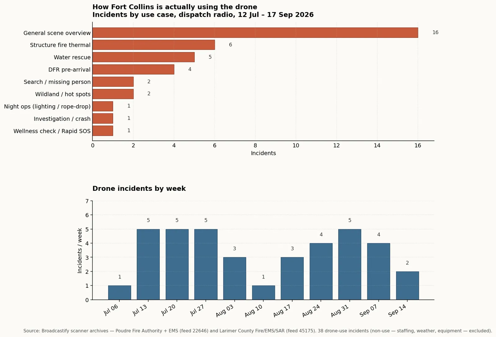
Across the tape, the drone was actually deployed on 38 distinct incidents in the two-month window — an average of about one every other day. Structure-fire thermal sweeps are the most common named job (6), followed by water rescues (5) and DFR pre-arrivals (4). The largest bar — "general scene overview" (16) — is incidents where the drone was up but the radio chatter didn't pin down a specific role. Non-use events (staffing gaps, weather cancels, equipment problems) are excluded from the chart.
Use case 1 — Structure fire thermal imaging on roofs
The single most common drone deployment in the tape is putting a thermal camera on a roof to look for hot spots or verify the fire is knocked down. Ground crews then avoid a ladder trip they don't need.
- 2026-07-13, 12:50 — Command asks: "Can you break them free to come grab the drone out of Battalion 1 and just get a look-see at the roof?"
- 2026-07-13, 14:44 — On the same fire, hours later: "Do you have time and resources to put the drone up and look for hot spots that are fired?"
- 2026-09-02, 05:58 — Post-knockdown thermal sweep confirms clean roof.
- 2026-09-11, 01:55 — DFR launched to a structure fire alongside first units; at 01:56 a "south 360" walk-around finds nothing visible from the exterior, with the drone giving the top-down complement.
The consistent pattern: drone up, thermal link to a phone or a screen next to the command rig, ground crews adjust based on what the camera sees.
Use case 2 — Wildfire and undeveloped-land hot spot search
Same thermal capability, different terrain. When crews knock down a fire in brush or on a hillside, the drone flies a search grid to find residual heat before the crews release the scene.
- 2026-09-02, 14:49–15:21 — On a fire with visible hot spots after initial attack: "Man north, do we have a drone so we can get an eye on some hot spots?" → "Yeah, county's bringing in a drone here in a little bit." → "Get a drone fly up. Looks like we have numerous hot spots." → "Copy. I've got Ops 4 on scene. We're going to have him fly his drone." → "We're going to fly a drone and get it measured officially." That last transmission is a second, quieter use of the same footage: producing the official fire-size measurement for the incident report.
- 2026-08-06, 20:47 — "If you're watching the drone feed, are you seeing the path through this fire from where your rigs are?" The drone is being used as a live map for ground crews picking their route through the burn.
Use case 3 — Missing person / search operations
The Prospect Mountain search on July 14 is the largest single deployment visible in the tape. Both Poudre Fire1 and Larimer County Fire/EMS/SAR2 channels carried matching traffic:
"They've got resources around Prospect Mountain from multiple directions and PD is launching a drone as well." — PFA, 2026-07-14 22:30:23
"Yeah, nothing found after looking for this from multiple angles. In addition, they had two drones with thermal imaging covering the majority of the mountain." — Larimer Fire/EMS/SAR, 2026-07-14 22:52:29
Two drones with thermal, covering "the majority of the mountain," and the search still came up empty. That is the answer to a question a reader is likely to ask: with thermal cameras, why don't they find everyone? Sometimes they don't.
A second search, five days later, is more legible in the tape as a directed search rather than a sweep:
"Bravo 30, copy. Drone in the air at 2336." — Larimer Fire/EMS/SAR, 2026-07-19 23:37:58
"If you can see the drone, what we're looking at is directly under the drone." — Larimer Fire/EMS/SAR, 2026-07-19 23:45:16
Ground units guided to the subject by radio while a drone circled overhead.
A 2026-09-06 call ended similarly to Prospect Mountain: "We do have the drone on scene and we're not able to locate anyone."
Use case 4 — Water rescue on Horsetooth Reservoir
The tape's most operationally rich drone deployment is a 2026-08-01 vessel-down call at Horsetooth. Radios show the drone doing four different jobs on the same incident, in the same hour, and reveal that PFA operates at least three distinct drones, each with a specialized payload.
"292 Engine 4, [an officer] is a drone pilot. When you get here, we can fly the drone off your rig." — PFA, 2026-08-01 20:38:42
"Command Engine 4, we're right behind you. We have two swimmers ready. If you want, we can try to see if we can get on a boat if needed, but we do also have a drone pilot with us that's ready with Battalion 2 when they arrive." — Larimer Fire/EMS/SAR, 2026-08-01 20:39:43
An hour later, over on the equipment side:
"Those are two separate drones. I can turn back and grab the drone for the line if you want that." — PFA, 2026-07-23 22:12:33
"Hey, the drone that does the rope drop is a completely separate drone. Do you want me to turn around and go get that drone as well?" — PFA, 2026-07-23 22:13:51
That exchange is from a July 23 call, not August 1, but it establishes the fleet: PFA has (at minimum)
- A camera / thermal drone — the workhorse for roofs and hot spots.
- A lighting drone — carries a light package for after-dark scene illumination. From the same July 23 call: "I'm headed up there with my drone for lighting..."
- A rope-drop drone — capable of carrying a line to a subject or across a gap. "...deliver their carrier line across with the drone too, so we'll see when we get up there what they want to do."
Use case 5 — Scene lighting after dark
Called out directly in the July 23 traffic quoted above. "Does a drone come with a lighting package on it?" — the answer, based on the same crew turning back to fetch the right aircraft, is yes.
Use case 6 — Traffic accidents and crash investigation
- 2026-08-28, 13:27 — After a fire: "We're the only fire unit remaining on scene. [Fort Collins] PD is going to fly the drone and do some investigation, and we're going to be here for a while." The city's investigators use drone footage as part of the cause workup.
- 2026-09-05, 13:21 — "Yeah, if we could just get some drone footage and you could send it to me, that would be super helpful for our investigation."
Use case 7 — Drone as First Responder: getting eyes on before the engine arrives
The DFR concept — launch immediately, arrive before ground units, video-link to the responding rigs — is threaded through the entire tape. A few of the cleanest examples:
"We have the DCR on scene. The southeast corner, Harmony and Ziegler in the pond." — PFA, 2026-07-24 05:50:18 (Stillwater Rescue call.)
"DCR is overhead, the vehicle in question is..." — PFA, 2026-07-26 14:08:58
"We have DCR en route, and we sent you guys the links for it." — PFA, 2026-09-02 05:56:03
"We have the DCR on scene. It looks like it's going to actually be a male wearing gray long sleeves and black pants." — PFA, 2026-09-11 19:31:25
That last transmission is where the operational value and the civil-liberties question meet: the drone is providing a live physical description of a person on a public-safety call — the same capability that the Fort Collins privacy coalition has flagged when it appears in other contexts.
A 2026-09-09 call shows the DFR being redirected mid-flight:
"Can you guys have the DCR fly over to the Shell gas station on Conifer and check that? I just noticed in the comments she said Shell, so possibly it's there." — Larimer Fire/EMS/SAR, 2026-09-09 14:26:00
"That's AFIRM. Her rapid SOS is showing her now at Columbine in LaPorte. I think there's going to be possibly a 7-Eleven that's nearby there. We're trying to get the DCR there before the battery dies." — Larimer Fire/EMS/SAR, 2026-09-09 14:27:50
The DFR is racing a cell phone battery to reach a caller whose location is coming in from Rapid SOS. This is a wellness-check use case — a person in distress, an airborne camera trying to find them before they lose the ability to communicate.
What limits the drones
The tape is honest about failure modes, which is useful for a piece meant to describe capability rather than sell it.
Staffing. "We unfortunately don't have staffing for the drone." (PFA, 2026-07-13) Certified operators are not always on-shift. That is why the police so often get the fly-request — a sheriff's deputy on patrol with a drone in the trunk is a faster resource than waiting for a PFA pilot to be pulled in.
Which brings up the sheriff-deputy carve-out, from a 2026-07-30 structure or wildland incident in Livermore:
"Street deputies have one that are available. We kind of have to bring someone in to bring one of our drones up." — PFA, 2026-07-30 17:54:46
"Our deputy, the tourist, does not have a drone either, so we're on foot patrol." — PFA, 2026-07-30 17:54:54
"You should have a drone." — PFA, 2026-07-30 17:56:12
Not every deputy vehicle carries one. Which deputy is on-shift determines whether there's an aircraft in reach.
Weather — specifically wind. From a July 15 call:
"winds our drone is not able to be flown. I've got two units that just arrived at..." — Larimer Fire/EMS/SAR, 2026-07-15 22:22:20
Small unmanned aircraft have hard wind limits.
Range. On a September 5 water rescue at Horsetooth:
"We cannot get the drone over the boat due to the range. Is there a way we can have a boat come meet us in quarry and take the drone pilot over so we can get better range on the drone." — PFA, 2026-09-05 13:45:41 and 13:45:51
The drone pilot literally had to be shuttled by boat to fly closer to the subject.
Reliability. "This drone is also en route, just having some problems." (PFA, 2026-09-08) "Drone is interrupted as well." (PFA, 2026-08-27)
The tape is not a highlight reel. Sometimes the aircraft doesn't work.
What the operational picture looks like
Pulling the two months together:
- Drones are treated as shared resources across agencies. PFA asks, sheriff or PD flies. Video links back to whoever needs the picture.
- PFA runs a fleet with at least three specialized payloads — camera/thermal, lighting, rope-drop.
- DFR (dispatched as "the DCR" through the transcription) is standard on the higher-severity calls: structure fires, wellness checks, water rescues, missing persons. Turnaround from radio request to live video is often under fifteen minutes.
- Common jobs: roof thermal on structure fires, hot-spot search on wildland, scene overview for size-up, missing-person search with thermal, wellness-check location assist, crash-scene investigation footage.
- Limits are staffing (certified operator on-shift), wind, aircraft range, and occasional equipment failure.
- Between July 12 and September 17, 2026, the drone shows up on the radio 130 times12.
Sources
Radio quotations above are transcribed transmissions from Broadcastify's publicly recorded archive of local dispatch, from two feeds — Poudre Fire Authority + EMS1 and Larimer County Fire/EMS/SAR2.
Program and equipment background:
- Fort Collins Drone as a City Resource Program — announcement
- Skydio X10 technical specifications — Skydio